

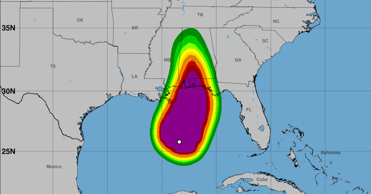
Hurricane Isaias was close to becoming a major hurricane Friday as it headed for the northern U.S. Gulf Coast, where the National Hurricane Center expects it to make landfall Friday night or early Saturday.
The center told people in storm surge and hurricane warning areas to have their preparations done within a few hours. Between the Alabama-Florida line and Grayton Beach, Florida, water could rise 6 to 9 feet above ground if the surge peaks at high tide.
Air Force Reserve Hurricane Hunters found maximum sustained winds near 110 mph, with higher gusts. Dropsonde data from the mission put the minimum central pressure at 958 millibars.
At 7 a.m. CDT, Isaias was centered about 245 miles south of Pensacola, Florida, and moving north-northeast at 15 mph. That put it 170 miles south-southeast of the mouth of the Mississippi River.
Forecasters expect a turn to the north later Friday. On its forecast track, the storm approaches the coast in the afternoon, and the center said it is likely to become a major hurricane Friday morning and still be dangerous at landfall.
Tropical storm-force winds extend up to 185 miles from the center. Hurricane-force winds reach out 30 miles.
Storm surge
The storm surge warning runs from the mouth of the Mississippi River east to Florida’s Suwannee River. A surge watch continues from there to Yankeetown.
Forecasters put possible surge at 4 to 7 feet between Grayton Beach and Indian Pass, Florida, and 4 to 6 feet from Indian Pass to the Steinhatchee River. It tapers to 3 to 5 feet between the Steinhatchee and the Suwannee, then 2 to 4 feet from the Suwannee to Yankeetown.
Alabama faces 4 to 6 feet from Dauphin Island to the Florida line. Mobile Bay could see 3 to 5 feet, as could the coast from the mouth of the Mississippi to Dauphin Island.
All of those figures assume the peak arrives with high tide. The deepest water would come right at the shoreline in areas of onshore wind, where large waves will add to the danger.
Because flooding depends on when the surge hits relative to the tide, conditions can differ a lot within a short distance.
The hurricane center described the surge as a life-threatening situation. Residents in the warning area were told to promptly follow evacuation and other directions from local officials.
Wind, rain and tornadoes
The hurricane warning covers Ocean Springs, Mississippi, to the Bay/Gulf County line in Florida. Tropical storm conditions are due there later Friday, with hurricane conditions Friday night into early Saturday.
On either side, tropical storm warnings extend west to Louisiana’s Jefferson/Plaquemines Parish line and east to Florida’s Aucilla River. Those areas should see tropical storm conditions starting in the next few hours.
Southern Alabama, the Florida Panhandle and Big Bend, and southwest Georgia could get 4 to 8 inches of rain through the weekend. Heavier bands may push totals to 15 inches in the Panhandle and Big Bend.
The rest of the Southeast is in line for 2 to 5 inches, and up to 10 in spots, particularly the Southern Appalachians and coastal Carolinas.
Flash and urban flooding are likely. Forecasters warned of possibly considerable impacts over much of southern Alabama and the Panhandle into southwest Georgia, along with river flooding that could turn significant in places.
Tornadoes could start late Friday afternoon in coastal Alabama, the Panhandle and far southwest Georgia. The risk continues Saturday across parts of eastern Alabama, the Panhandle, Georgia and the Carolinas.
Swells already hitting parts of the western and northern Yucatan Peninsula will spread north toward the Gulf Coast later Friday. They are likely to bring life-threatening surf and rip currents.
Editor’s Note: AI assisted with research, organization and initial drafting. Virginia Times verified the information and is responsible for the final story.