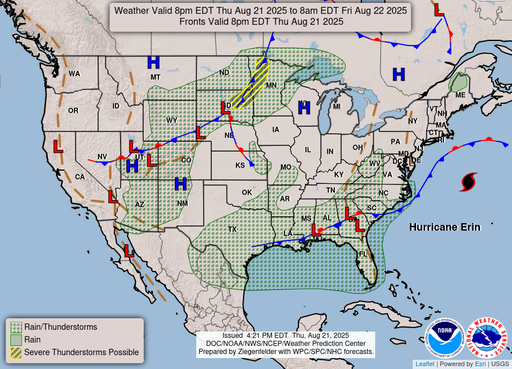
- Erin (100 mph) is moving northeast between the U.S. East Coast and Bermuda. It is forecast to weaken slowly and become post-tropical on Saturday.
- Storm Surge Warning: Cape Lookout to Duck, N.C.; Tropical Storm Warning: Duck, N.C., to Chincoteague, Va., and Bermuda.
- Life-threatening surf and rip currents throughout most East Coast beaches through at least Friday; gusts to tropical-storm force probable into southern New England.
THE BIG PICTURE
According to the National Hurricane Center, Hurricane Erin was located near 36.4°N, 69.1°W on Thursday, Aug. 21, 2025, at 5 PM AST (2100 UTC). It had maximum sustained winds of 100 mph and was heading northeast at 20 mph.
The big storm will move across the western Atlantic between the U.S. East Coast and Bermuda until early Friday. Then it will move south of Atlantic Canada from Friday to Saturday. Hurricane-force winds can reach up to 105 miles from the center, while tropical-storm-force winds can reach up to 320 miles.Forecasters indicate that Erin will slowly lose strength over the next few days and become post-tropical on Saturday.As the swells move north, dangerous surf and strong rip currents are likely to stay along a large part of the East Coast.
WHAT’S NEW
The Tropical Storm Warning south of Duck, N.C., is no longer in force. However, the Storm Surge Warning is still in place from Cape Lookout to Duck, N.C.
A Tropical Storm Warning is still in effect for Bermuda and the area from Duck, North Carolina, to Chincoteague, Virginia.
As Erin moves northeast, winds over sections of the Mid-Atlantic and southern New England shores could reach tropical-storm force by early Friday.
A different pattern will bring sporadic thunderstorms accompanying slow-moving fronts from the Southeast to Texas later in the week. There is a small chance of too much rain in certain regions of Georgia and South Carolina on Friday.The deadly heat wave will last over the weekend in the West’s interior.
WHAT THEY’RE TALKING ABOUT
CONTEXT:
From Cape Lookout to Duck, N.C., there could be a storm surge of 2 to 4 feet above ground. This is where the water is deepest and the waves are biggest along the coast. Tropical storm conditions will continue to hit parts of the North Carolina and Virginia coast for the next few hours. The Mid-Atlantic and southern New England may also experience strong gusts further north. Bermuda will be under tropical storm conditions until early Friday.People in Atlantic Canada should pay attention to local news, as gale-force winds could hit parts of Nova Scotia on Friday and Newfoundland on Saturday.
Dangerous maritime conditions are present far from the center.Swells hitting the Bahamas, Bermuda, the U.S. East Coast, and Atlantic Canada will keep the risk of rip currents high until at least Friday.The Weather Prediction Center also points out a line of showers and thunderstorms along stalled borders in the Southeast, Gulf Coast, and Texas. It also warns of severe temperatures throughout much of the West.
WHAT’S NEXT?
Erin will move faster to the northeast and east-northeast, passing south of Atlantic Canada from Friday to Saturday. It will weaken and become a post-tropical storm.
Beach dangers, especially rip currents, will be behind the storm’s path and may stay high over the weekend.
People who live in or visit the area should follow the evacuation and safety advice given by local officials and check with the National Weather Service offices in their area for site-specific warnings.
THE FINAL WORD
Erin is not going to hit the U.S. shore, but its strong winds and big waves represent a severe threat to the coast.
Areas of North Carolina’s Outer Banks could experience storm surge, while areas of the Mid-Atlantic shoreline and Bermuda may still encounter tropical-storm conditions; additionally, dangerous surf and rip currents will persist along the entire East Coast.
Follow Virginia Times for regular news updates. Stay informed with the latest headlines, breaking stories, and in-depth reporting from around the world.
A global media for the latest news, entertainment, music fashion, and more.


