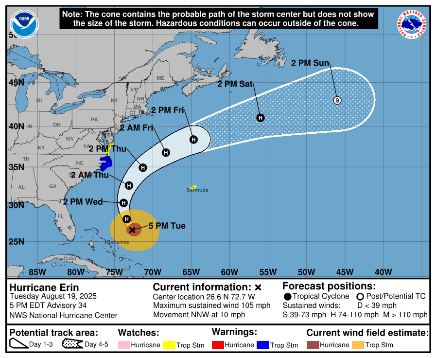
- 5 p.m. ET Tue., Aug. 19: Erin was about 615 miles south-southeast of Cape Hatteras, N.C., with sustained winds near 105 mph, moving NNW at 10 mph.
- Alerts: Storm Surge Warning Cape Lookout–Duck, N.C.; Tropical Storm Warning Beaufort Inlet–Duck including Pamlico & Albemarle Sounds; Tropical Storm Watch extended north to Chincoteague, Va.; Bermuda under a Tropical Storm Watch.
- Beach hazards: Life-threatening rip currents and dangerous surf will affect much of the U.S. East Coast and Atlantic Canada for several days.
The Big Picture
Hurricane Erin remains a large Category 2 system over the western Atlantic and will pass east of the Bahamas tonight before tracking between the U.S. East Coast and Bermuda Wednesday into Thursday, according to the National Hurricane Center. At 5 p.m. ET, the center was near 26.6°N, 72.7°W—about 615 miles from both Bermuda and Cape Hatteras—with maximum sustained winds near 105 mph, a minimum central pressure of 958 mb, and forward motion to the north-northwest near 10 mph.
What’s New
The Tropical Storm Watch has been extended northward along the Mid-Atlantic coast to Chincoteague, Virginia. The Bermuda Weather Service has issued a Tropical Storm Watch for the island. A Storm Surge Warning remains in effect from Cape Lookout to Duck, N.C., and a Tropical Storm Warning covers Beaufort Inlet to Duck, including the Pamlico and Albemarle Sounds. Rainfall will diminish across the Turks and Caicos and the Bahamas this evening; on North Carolina’s Outer Banks, 1–2 inches of rain is possible Wednesday night into Thursday. Swells from Erin will continue to build, producing life-threatening rip currents.
What They’re Saying
Context
Erin’s wind field is broad: hurricane-force winds extend outward up to 80 miles from the center and tropical-storm-force winds up to 230 miles. On the present track, the cyclone stays offshore but close enough to push long-period swells into the Carolinas, the Mid-Atlantic, southern New England, and Bermuda. If peak surge arrives at high tide, 2–4 feet of inundation is possible from Cape Lookout to Duck. Tropical-storm conditions are expected over parts of the Outer Banks late Wednesday into Wednesday night, and are possible from north of Duck to Chincoteague on Thursday; tropical-storm conditions are also possible in Bermuda beginning Thursday.
What’s Next
Complete coastal preparations in the North Carolina warning area and follow local orders. Beach and boating conditions will remain dangerous well ahead of the center. Interests along the Mid-Atlantic and southern New England coasts—and in Bermuda—should monitor updates as watches and warnings are adjusted.
The Bottom Line
Erin will remain offshore but will still bring hazardous surf, rip currents, coastal flooding, and periods of wind and rain—especially for the Outer Banks and parts of the Delmarva coast. Treat the surge and beach hazards seriously and stay aligned with local guidance through late week.
A global media for the latest news, entertainment, music fashion, and more.


