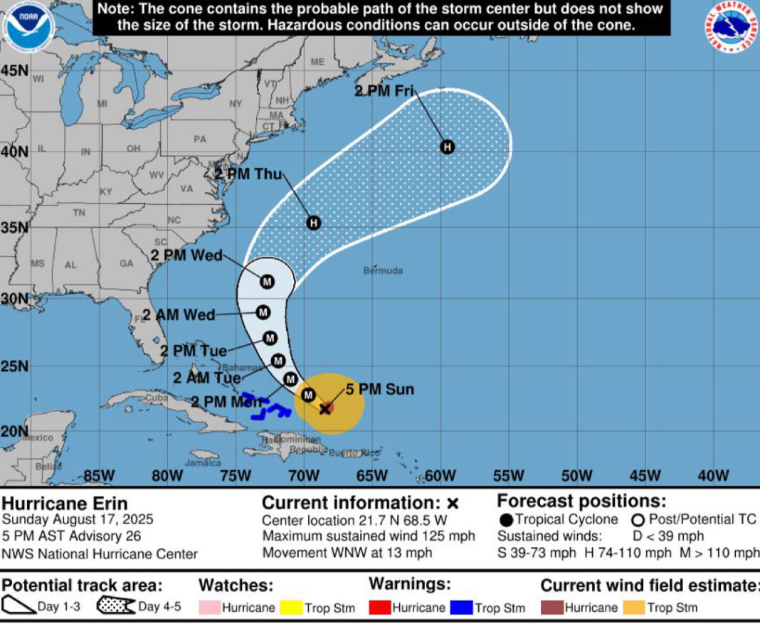
- 5 p.m. ET Sun: Erin is a Category 3 with 125 mph winds; hurricane-force winds extend 50 miles, tropical-storm-force out to 205 miles.
- Tropical Storm Warnings: Turks and Caicos, Southeast Bahamas. The large storm will grow in size while staying offshore.
- Dare County (N.C.) issues State of Emergency; mandatory evacuations for Hatteras Island begin Monday (visitors) and Tuesday (residents); long-duration coastal flooding and ocean overwash expected.
The Big Picture
As of the 5 p.m. advisory from the National Hurricane Center, Hurricane Erin is a Category 3 with maximum sustained winds of 125 mph and a minimum central pressure of 946 mb. At 21.7°N, 68.5°W, Erin was moving WNW at 13 mph, about 275 miles northwest of San Juan, Puerto Rico, and 165 miles east of Grand Turk. Hurricane-force winds extend up to 50 miles from the center; tropical-storm-force winds extend up to 205 miles.
What’s New
Tropical Storm Warnings are in effect for the Turks and Caicos and the Southeast Bahamas. Tropical-storm conditions are expected to begin tonight into Monday, with heavy rain totals of 2–4 inches and localized amounts up to 6 inches possible. Outer rainbands continue over Puerto Rico with an additional 2–4 inches possible through Monday, raising the risk of flash flooding and landslides.
Dare County, North Carolina, declared a State of Emergency Sunday and ordered mandatory evacuations for Hatteras Island (Zone A). Visitors must evacuate starting 10:00 a.m. Monday, Aug. 18; residents start 8:00 a.m. Tuesday, Aug. 19. Officials warn portions of N.C. Highway 12 may be impassable for several days as coastal flooding and overwash peak Tuesday through Thursday.
What They’re Saying
#Erin is expected to produce life-threatening surf and rip currents along the beaches of the Bahamas, much of the east coast of the U.S., and Atlantic Canada next week for latest beach forecast visit https://t.co/JttG4XipJ4 pic.twitter.com/YsBZF74IAD
— National Hurricane Center (@NHC_Atlantic) August 16, 2025
Context
Erin has undergone striking changes in a short window. The storm briefly reached Category 5 status on Saturday before weakening to Category 3 on Sunday while expanding in size over the western Atlantic. It intensified from Category 1 (75 mph) late Friday to near 160 mph just over 24 hours later—among the fastest-strengthening Atlantic hurricanes on record before September 1. Rapid intensification events have become more common in recent years as ocean and atmospheric conditions warm.
Erin is also one of the rare Category 5 hurricanes on record in the Atlantic and the fourth straight season to feature a Category 5, following Beryl and Milton last year. While a U.S. landfall is not expected, large swells, long-period waves, and strong rip currents pose significant danger well away from the storm’s center.
What’s Next
Erin will turn northwest and then north Monday–Tuesday, passing east and northeast of the Turks and Caicos and the southeast Bahamas. The large storm is likely to intensify again and remains a major hurricane through midweek while curving between the U.S. East Coast and Bermuda. Even without a direct U.S. hit, expect rip currents to increase first—often before larger waves arrive—spreading from the Southeast on Monday to the Mid-Atlantic and Northeast later in the week. Check local beach forecasts and heed flags and advisories.
The Bottom Line
Erin is a powerful, expanding hurricane over the western Atlantic. The main U.S. threats this week are life-threatening rip currents, dangerous surf, beach erosion, and periods of coastal flooding—especially along the Outer Banks—despite the storm staying offshore.


