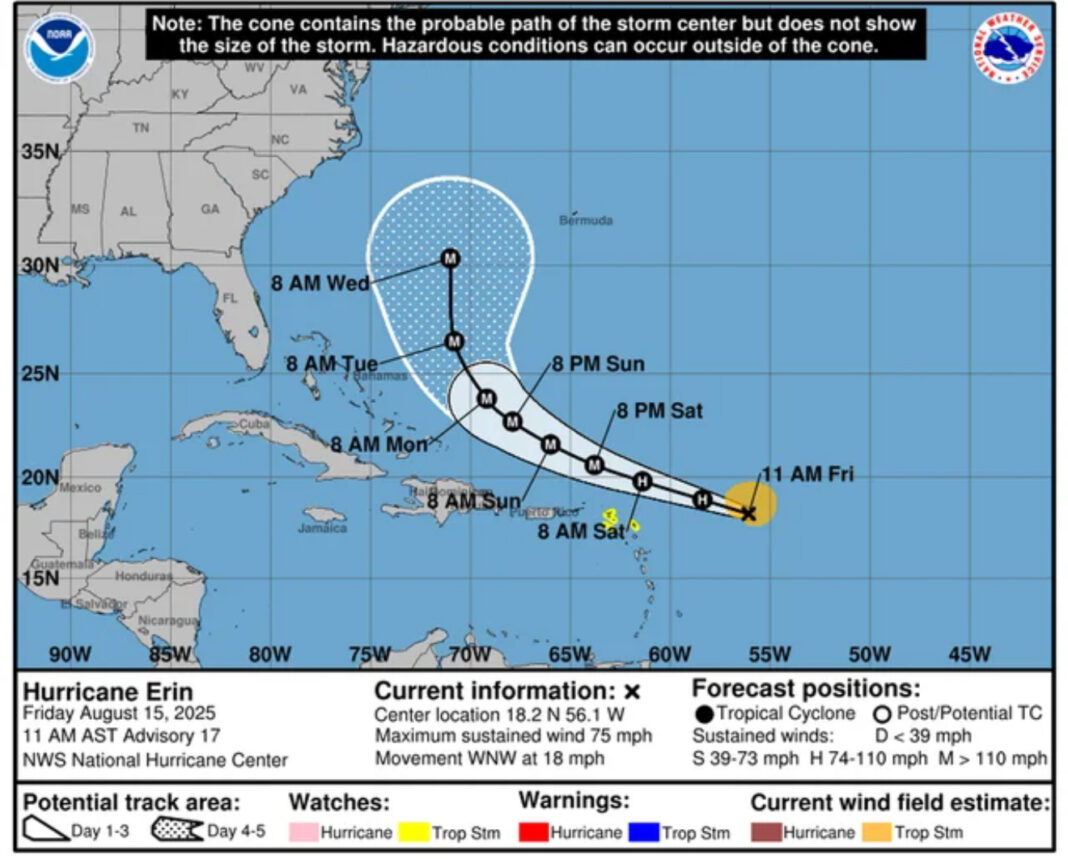
- Erin strengthened to a hurricane at 11 a.m. AST Friday with 75 mph winds, located ~460 miles east of the northern Leewards.
- Tropical Storm Watches: Anguilla and Barbuda; St. Martin & St. Barthelemy; Saba & St. Eustatius; Sint Maarten.
- Forecast: passes near or north of the Leewards Saturday; swells and rip currents for the Virgin Islands and Puerto Rico this weekend; intensification to major hurricane likely.
The Big Picture
Hurricane Erin became the first Atlantic hurricane of the 2025 season with maximum sustained winds of 75 mph in the 11 a.m. AST Friday advisory, situated about 460 miles east of the northern Leeward Islands, moving WNW at 18 mph, according to the National Hurricane Center. Guidance keeps the center passing near or just north of the Leewards on Saturday before curving northward over open Atlantic waters early next week.
What’s New
Tropical Storm Watches are now posted for Anguilla and Barbuda; St. Martin and St. Barthelemy; Saba and St. Eustatius; and Sint Maarten, the hurricane center said. Swells will reach the northern Leeward Islands, the Virgin Islands, and Puerto Rico this weekend, bringing dangerous surf and rip currents. Heavy rain bands could trigger localized flash flooding and mudslides on steeper terrain even if the core stays offshore. The center’s forecast calls for continued strengthening, with Erin likely to reach major hurricane status late this weekend.
What They’re Saying
Context
This season was already primed for activity: NOAA’s updated August outlook keeps the Atlantic on track for an above-normal year, citing warm ocean temperatures and supportive atmospheric patterns (NOAA). That backdrop raises the odds that systems like Erin can intensify quickly when conditions align.
What’s Next
Residents and visitors across the northern Leewards should prepare for tropical-storm-force gusts, squalls, and hazardous seas as Erin passes to the north on Saturday. The Virgin Islands and Puerto Rico face high surf, strong rip currents, and periods of heavy rain into Sunday. Farther ahead, interests in Bermuda should monitor updates early to mid-week as the system gains strength over the open Atlantic. Beachgoers along the U.S. East Coast can expect building swells and stronger rip currents next week, the hurricane center noted.
The Bottom Line
Erin is strengthening and staying just north of the Caribbean’s most populated islands, but its size and seas will be felt well beyond the core. Heed local advisories, stay off dangerous surf, and follow official updates as the forecast evolves.
A global media for the latest news, entertainment, music fashion, and more.


