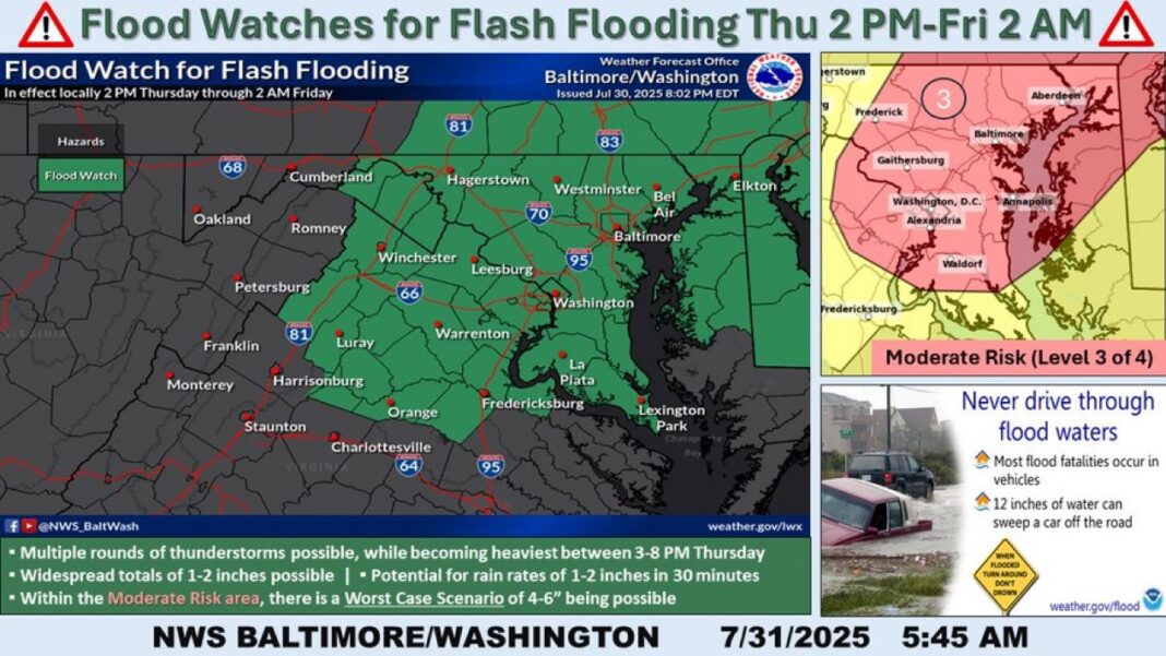
- Hazardous Weather Outlook and Flood Watch active from Thursday afternoon through early Friday.
- Widespread rain totals of 1–2 inches expected; some areas could see 4–6 inches.
- Heaviest rainfall likely between 3 p.m. and 8 p.m. Thursday.
- Potential for flash flooding, especially in low-lying and urban areas.
- Residents advised to clear drains, stay informed, and prepare evacuation plans.
Heaviest Rains Expected During Evening Commute
The National Weather Service has issued a Hazardous Weather Outlook and a Flood Watch for Fairfax County starting Thursday afternoon, July 31, through early Friday morning. Residents are being urged to remain alert as storms capable of producing intense rainfall could lead to dangerous flash flooding.
Forecast Details
According to the weather advisory, numerous showers and thunderstorms will develop over the region beginning early Thursday afternoon. The heaviest rainfall is expected between 3 p.m. and 8 p.m., coinciding with the evening rush hour. Thunderstorm cells are expected to deliver rainfall rates of 1 to 2 inches within 30 minutes, with some locations potentially experiencing multiple rounds of storms.
Widespread rainfall totals of 1 to 2 inches are forecasted, but isolated spots could see as much as 4 to 6 inches, creating high risk for flash flooding in both urban and rural areas.
What Officials Are Saying
“Please have a plan in place to seek higher ground immediately if flash flood warnings are issued,” the National Weather Service warned in its outlook for the region. The agency stressed the importance of being prepared in advance, especially during the busiest commuting hours.
Showers & strong to severe thunderstorms this afternoon & evening, primarily 1pm and 9pm. The metro areas of Baltimore, MD and The District of Columbia will be the focus for possible Flash Flooding. Flood Watch in effect northern Shenandoah Valley east to Chesapeake Bay. pic.twitter.com/ezgTY7lUbb
— NWS Baltimore-Washington (@NWS_BaltWash) July 31, 2025
Public Safety Reminders
Fairfax County officials have issued a public Flood Watch notice and recommend the following actions:
- ✔️ Clear leaves and debris from storm drains
- ✔️ Report non-VDOT blocked drains via this reporting link
- ✔️ Sign up for real-time alerts at Fairfax Alerts
The Bottom Line
Flash flooding remains the most dangerous and unpredictable threat during this weather pattern. Residents of Fairfax County and surrounding metro areas should stay vigilant, monitor local weather alerts, and avoid traveling through flooded roadways under any circumstances.
ICE Arrests 2025: CBS Report Reveals Trump-Era Immigration Enforcement Surge
Delta Flight Hit by Turbulence Makes Emergency Landing in Minneapolis
Follow Virginia Times for regular news updates. Stay informed with the latest headlines, breaking stories, and in-depth reporting from around the world.
A global media for the latest news, entertainment, music fashion, and more.


